Overseas Business
2021년 12월 08일 2021-12-09 16:13Overseas Business
Home
Business
Overseas Business
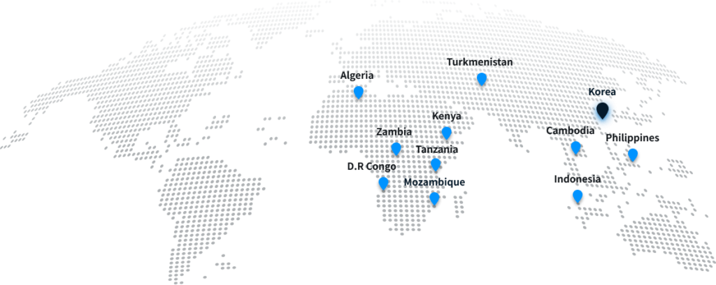
If you mouse over the location of the country, you can see the business performance.


Mozambique
2012 Mozambique Maputo City Gas Project Design Service
2014 Zambezi Regional Map Project
2016~2020 African Minerals Geoscience Initiative Pilot Project
· Satellite and aerial image based 1/25,000 National Base Map, 1/2,500 digital map
and ortho photo production
· Surveying LPG supply chain underground facility and establish DB of 3D underground geospatial information in Maputoshi, the capital city

Tanzania
2016~2020 African Minerals Geoscience Initiative Pilot Project
· Building 3D resource spatial information DB such as satellite and aerial image based digital topographic map/MGCP data.

Kenya
2011 Digital Map product in LamuPort
· Production of 3D spatial data and national basie maps such as 1/1,000 digital maps and digital elevation models based on aerial survey and LiDAR

D.R Congo
2009 A Project to Establish Geographic Information System in D.R Congo
· Establish a master plan to build a National Geodetic Network in D.R Congo

Turkmenistan
2012 A Project to Establish City Total Control Center in Turkmenistan
2013 A Project to Construct Safe City in Turkmenistan
· Production of 1/1,000 digital map based on aerial survey
· Establishment of urban safety DB including CCTV, traffic, and control

Philippines
2013 Construction GIS for Water Resource Management in Philippines
· Construction of 3D spatial information DB for water resource disaster prevention and management system based on aerial photogrammetry

Zambia
2016~2020 African Minerals Geoscience Initiative Pilot Project
· Building 3D resource spatial information DB such as satellite and aerial image based digital topographic map/MGCP data

Algeria
2009 Design Service for Algeria East–West Highway
· Surveying and building spatial data for the new design of Algeria East–West Highway

Cambodia
2010 Master Plan for New Siem Reap Airport in Cambodia
· Building spatial data for the new Siem Reap construction master plan

Indonesia
2010 Master plan for sumatraisland in Indonesia
· Establishment of GIS DB for the production of main road network on Sumatra Island in Indonesia
korea


Tanzania
2016-2020 African Minerals Geoscience Initiative Pilot Project
· Building 3D resource spatial information DB such as satellite and aerial image based digital topographic map/MGCP data.

Mozambique
2012 Mozambique Maputo City Gas Project Design Service
2014 Zambezi Regional Map Project
2016-2020 African Minerals Geoscience Initiative Pilot Project
· Satellite and aerial image based 1/25,000 National Base Map, 1/2,500 digital map and ortho photo production
· Surveying LPG supply chain underground facility and establish DB of 3D underground geospatial information in Maputoshi, the capital city

Kenya
2011 Digital Map product in LamuPort
· Production of 3D spatial data and national basie maps such as 1/1,000 digital maps and digital elevation models based on aerial survey and LiDAR

Zambia
2016 & 2017 African Minerals Geoscience Initiative Pilot Project
· Building 3D resource spatial information DB such as satellite and aerial image based digital topographic map/MGCP data.

D.R Congo
2009 A Project to Establish Geographic Information System in D.R Congo
· Establish a master plan to build a National Geodetic Network in D.R Congo

Algeria
2009 Design Service for Algeria East–West Highway
· Surveying and building spatial data for the new design of Algeria East–West Highway

Turkmenistan
2012 A Project to Establish City Total Control Center in Turkmenistan
2013 A Project to Construct Safe City in Turkmenistan
· Production of 1/1,000 digital map based on aerial survey

Cambodia
2010 Master Plan for New Siem Reap Airport in Cambodia
· Building spatial data for the new Siem Reap construction master plan

Philippines
2013 Construction GIS for Water Resource Management in Philippines
Construction of 3D spatial information DB for water resource disaster prevention and management system based on aerial photogrammetry

Indonesia
2010 Master plan for sumatraisland in Indonesia
· Establishment of GIS DB for the production of main road network on Sumatra Island in Indonesia

